Which view carries the evidence, where, and why?
When Satellite and Street Views Disagree: Cross-View Complementarity in Disaster Damage Assessment
Satellite and street-view imagery see different parts of a damaged building: roofs from above, facades and debris from the ground. Average accuracy hides whether fusion uses this complementary evidence. We study the conflict cases, where independently trained single-view models disagree, as a diagnostic subset across three real disasters. An oracle that picks the correct view per conflict stays 0.19–0.32 above the best fusion method. A linear fusion gate over building visibility recovers part of that headroom where ground photographs are aimed at the building, a controlled cropping experiment shows that framing is a driver, and the spatial density of conflicts tracks damage without labels.
News: the short paper has been accepted as a lightning talk at GeoSearch 2026 (5th ACM SIGSPATIAL Workshop on Searching and Mining Large Collections of Geospatial Data), Riverside, CA, 3 November 2026.
Central Thesis
Do not ask whether fusion helps. Ask which view carries the evidence, where, and why.
The two views are complementary: a facade can be gutted under an unbroken roof. Yet for most buildings in a paired street/overhead collection the views agree, so average accuracy says little about whether fusion uses view-specific evidence. The informative records are the conflict cases, the 10–33% of samples on which independently trained single-view models disagree. On a conflict, at least one view carries evidence the other lacks, whether damage is visible only from one side, vegetation hides the building, or the views are misaligned.
Framework
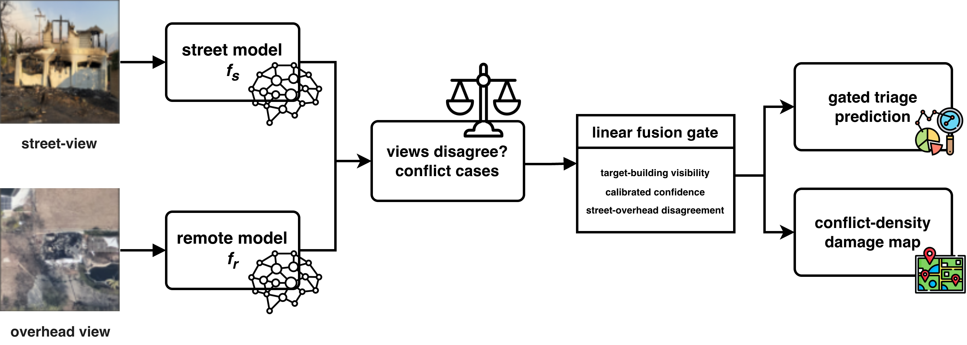
From conflict cases to a per-sample fusion weight and a map.
Independently trained street and remote models define the conflict cases. A linear gate over building visibility, calibrated confidence, and cross-view disagreement assigns each predictor a weight per sample. The spatial density of conflicts doubles as a damage map that needs no labels.
The Oracle Gap
Current fusion leaves most complementary evidence unused.
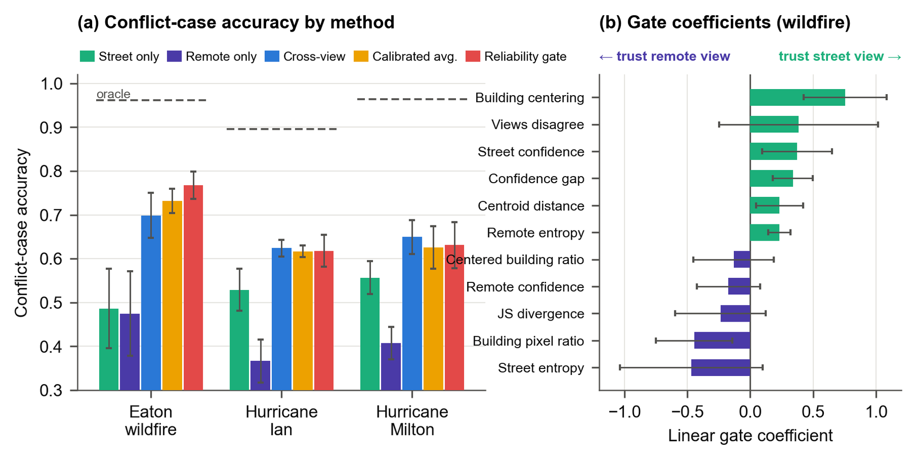
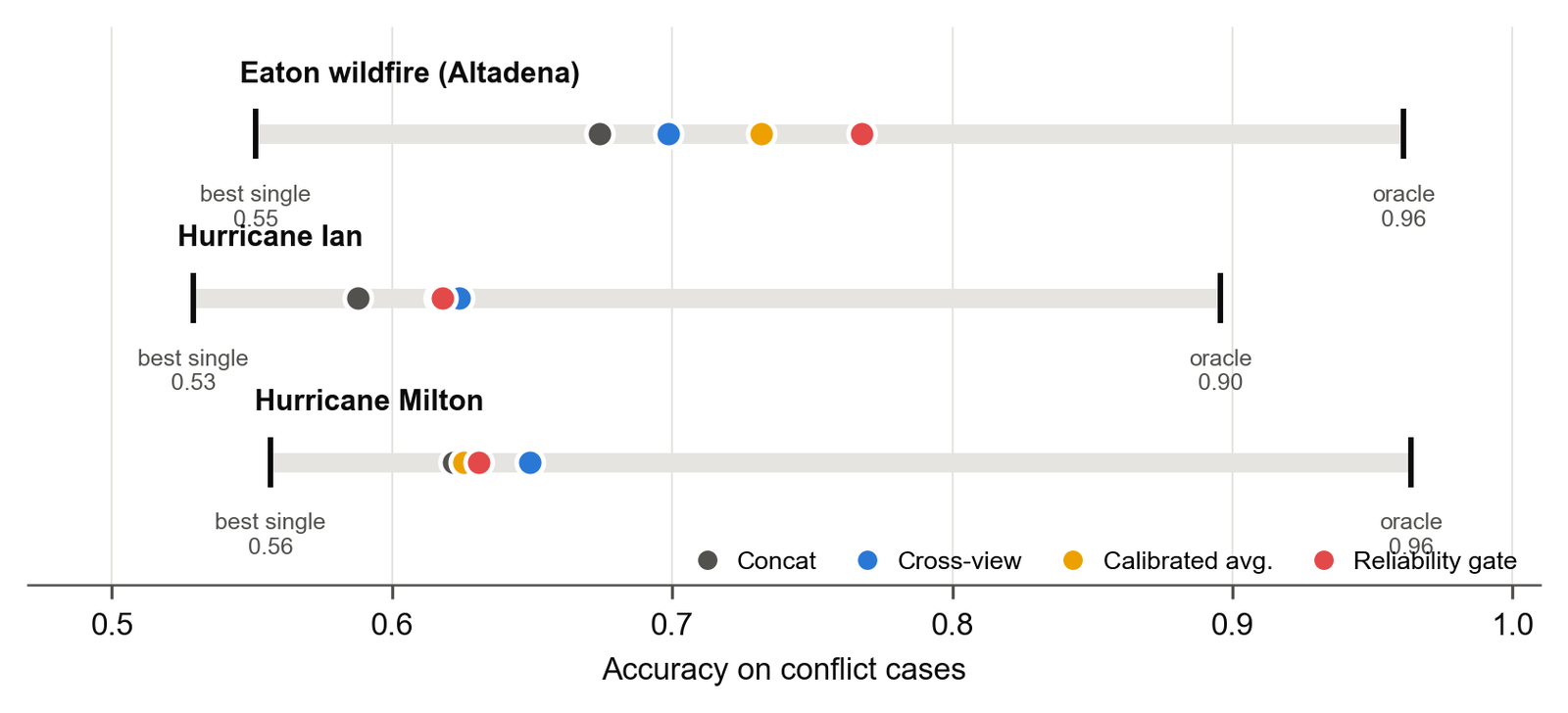
Fusion improves conflict accuracy over either view, but an oracle that picks whichever single view is correct per conflict sample exceeds the better single view by 0.37–0.48 and the best evaluated fusion method by 0.19–0.32. The oracle only chooses between two existing models, so this is a measure of view-specific evidence that fusion does not recover. Under converged, calibrated training, end-to-end learned fusion does not reliably beat calibrated probability averaging, a negative result worth absorbing.
closure(m) = [accC(m) − accC(best single)] / [accC(oracle) − accC(best single)]
- Conflict subset C
- Test samples where the street and remote argmax predictions differ: 9.6% (Eaton), 33.2% (Ian), 25.7% (Milton).
- Oracle
- Correct if either single view is correct. It only chooses which of two fixed models to use.
- Closure
- Fraction of the gap a method recovers. Computed from the five-seed means. Gate 0.59 on the wildfire; no method exceeds 0.26 on the panoramic datasets.
Fusion Gate
A linear gate over eleven interpretable features recovers part of the headroom where the ground view shows the building.
| Method | Eaton wildfire | Hurricane Ian | Hurricane Milton |
|---|---|---|---|
| street_only | 0.486 | 0.529 | 0.557 |
| remote_only | 0.475 | 0.367 | 0.407 |
| crossview (end-to-end fusion) | 0.699 | 0.624 | 0.649 |
| calibrated probability averaging | 0.732 | 0.617 | 0.626 |
| fusion gate (linear) | 0.768 | 0.618 | 0.631 |
| oracle single view | 0.961 | 0.896 | 0.964 |
Conflict-case accuracy, five-seed means. On the property-centric wildfire imagery the gate delivers +0.072 over end-to-end fusion and +0.051 over calibrated averaging (pooled sign-flip permutation tests, p ≤ 0.0001). On the panoramic hurricane imagery, where street views rarely see the target building, it is statistically indistinguishable from end-to-end fusion. The two-expert (street vs. overhead) variant reads as one rule: weight the street view when it is confident and the building is centered. Which view carries the evidence is thus a property of the capture setting, not of the sensor.
Field-of-View Intervention
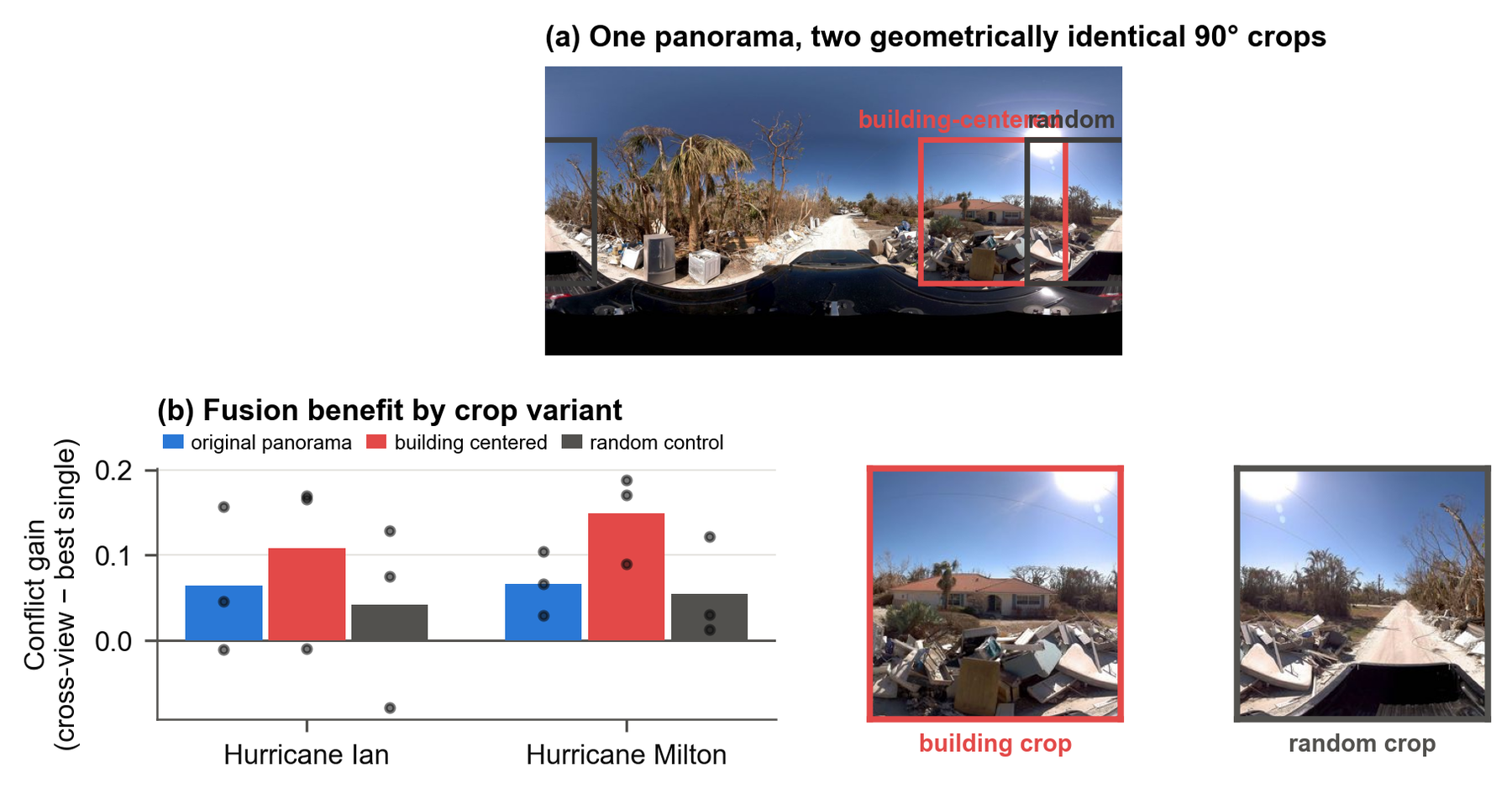
Aiming the ground view at the building changes which view carries the evidence.
Hurricane panoramas are cropped to 90° windows that are either centered on the detected building or placed at a random azimuth. The two variants are geometrically identical. Building-centered crops raise the conflict gain of fusion (Ian 0.064 → 0.109, Milton 0.067 → 0.149); random crops do not, and the building-minus-random contrast is positive in 6/6 dataset–seed pairs (three seeds, three-epoch schedule). The gain arrives even though building-centered crops lower street-only accuracy, so the gain does not come from a stronger street model. The segmenter locates built structures rather than the specific target building, so this supports, rather than proves, building-oriented framing as a driver of the regime difference.
Conflict Density as a Damage Map
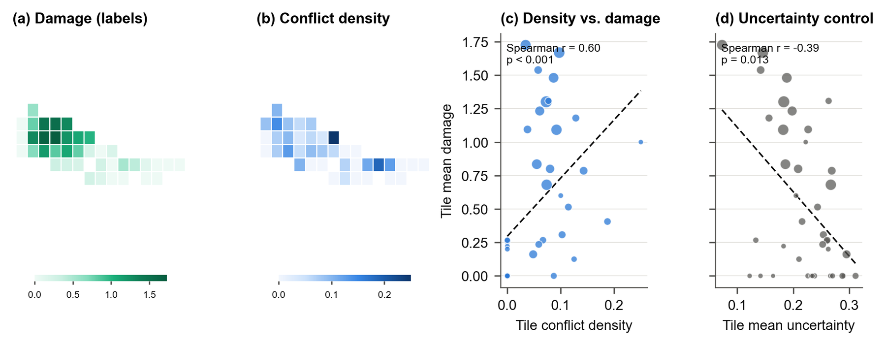
Where the views disagree is itself a spatial signal.
Aggregated to tiles, the fraction of conflict cases predicts wildfire damage without any labels (Spearman r = 0.615 over 25 overhead tiles; r = 0.60 on a 0.01° grid; nominal p-values, since damage is spatially autocorrelated). The hurricane signal is weaker (Milton r = 0.289, n.s.). The natural control fails in the most instructive way: single-view uncertainty anti-correlates with damage, because burned-to-the-ground parcels are easy, confident classifications. A conflict-density raster can be computed within hours of acquiring paired imagery.
Qualitative Evidence
Conflict cases show what each view can and cannot see.
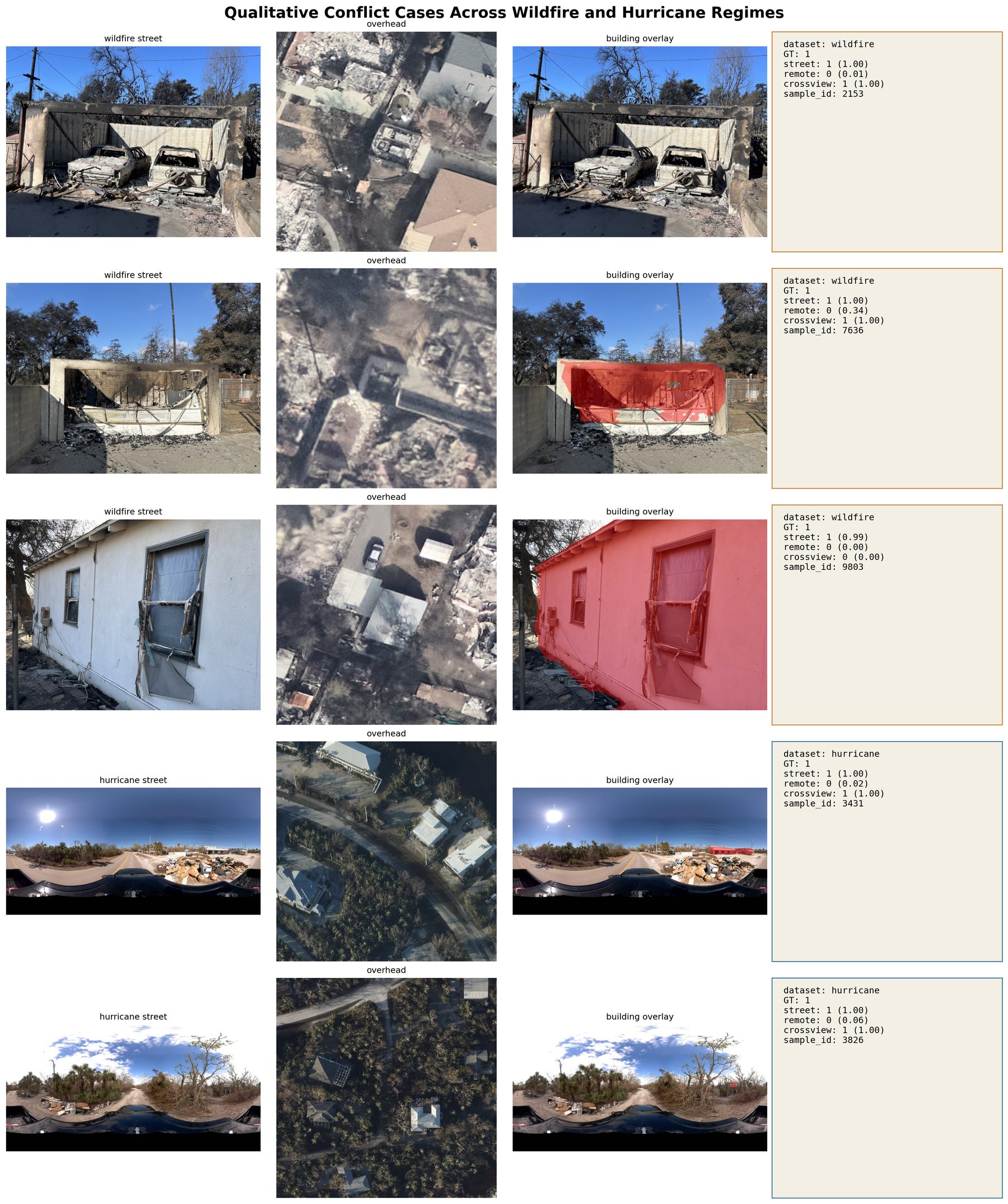
Street view, overhead patch, per-model predictions, and the building segmentation overlay that feeds the gate, for wildfire and hurricane conflicts resolved by fusion and one failure case.
Data and Protocol
Three disasters, two ground-view observation regimes, one converged protocol.
Eaton wildfire (Altadena, CA)
CAL FIRE Damage Inspection photographs from the January 2025 fire, paired with post-event VHR overhead tiles. Property-centric ground view; ordinal three-class task; split by property and tile.
Regimeproperty-centric
Conflict rate9.6%
Gate closure0.59
Hurricane Ian (CVIAN)
The released CVDisaster pairing: Mapillary panoramas over Sanibel Island with 27 cm satellite imagery. An audit against the official position GeoJSON showed the release split leaks Mapillary sequences; a repaired spatial-block split with a 25 m buffer lowers macro-F1 by 0.05–0.10.
Regimepanoramic
Conflict rate33.2%
Gate closure0.24
Hurricane Milton (FL)
Street-view panoramas paired with satellite tiles after the October 2024 hurricane, constructed analogously to CVIAN. The smallest dataset, which widens the gate's intervals.
Regimepanoramic
Conflict rate25.7%
Gate closure0.18
What This Work Claims
Mining conflicts turns “does fusion help?” into “which view carries the evidence, where, and why?”
- Evaluate fusion on the cases where the views disagree, and report how much of the oracle gap a method closes. That ratio measures how much complementary evidence fusion uses.
- Which view carries the evidence depends on hazard and capture setting: visibility cues identify when the street view is decisive on property-centric wildfire photographs; on panoramic hurricane imagery calibrated averaging or end-to-end fusion suffices.
- Once single-view models are converged and calibrated, simple averaging is a strong baseline; learning pays off when it decides per sample which view to weight.
- Building-oriented framing of the street view raises the value of fusion. Capture policy is itself a lever: aim cameras at structures.
- Conflict density is a label-free damage indicator on the wildfire that plain uncertainty does not replicate; it still needs spatially independent validation.
- Split by object and location. Release-style random or index-based splits overstate spatial generalization.